Hurricane Mountain Circuit in the Bob Marshall Wilderness
July 8-13, 2011
Copyright Notice

This wonderfully remote trek is within the Bob Marshall Wilderness. We started at the Swift Reservoir and hiked up the South Fork of Birch Creek. The circuit continued up Phone Creek, Seedling Creek then down Pot Shot Creek to the North Fork of Birch Creek. From there we trekked up Canyon Creek, down Sheep Creek and finished by hiking the Phillips Creek Trail back to the reservoir. Along the way we climbed some mountains, enjoyed great camps and swamp in the creeks.
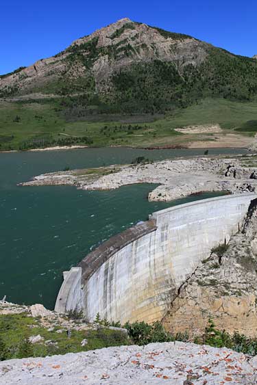
Swift Reservoir was full to the brim. Water was being pushed over the top of the dam by strong winds. Large rivers flow into the reservoir and we had to find a way across one of those. Above right, Denise and April braced against the wind.
Sentinel Mountain and Mount Phillips rise behind the Swift Reservoir.
After a hike of about 2.5 miles we came to the first of many stream crossings. This one was a simple rock hop.
Once above the reservoir we began the descent to the South fork of Birch Creek.
Whoa! This one was tough. We all got across but one had to do a little swimming with a pack.
We hiked a little further then set up camp and began drying out wet gear. The wind was helpful there but it also caused us a restless night.
Our second day would take us across the South Fork of Birch Creek three more times. This is our evening view up that valley. Fortunately all the following fords were uneventful.
The post Creek Falls. A delightful swimming hole.
A few miles up the South fork of Birch Creek we left that river and walked up Phone Creek. We stopped to camp at Happy Creek and climbed Hurricane Mountain in the late afternoon. Here Denise, myself and April are on the summit.
Looking southwest from the summit of Hurricane Mountain is a sea of peaks that include Mount Patrick Gass.
Looking back toward our first night's camp and Sentinel Mountain.
Denise on the summit ridge of Hurricane Mountain.
The following day we reached the saddle between Seedling Creek and Pot Shot Creek. We rested for a while then climbed Bennie Hill from there.. This is the view of Old Man of the Hills on the Rocky Mountain Front from the summit of Bennie Hill.
After enjoying a relaxing time on Bennie Hill we found a nice camp just below the saddle along Pot Shot Creek.
A few miles down Pot Shot Creek we came to the junction with Canyon Creek. It was only about 10 miles directly back to our trailhead but we stopped along the way for a little side trip.
The valley of Canyon Creek. Walling Reef is on the immediate left.
Once past the head of Canyon Creek we descended part way down Sheep Creek. Thunderstorms brought occasional rain but we didn't get too wet.
The skies cleared in the evening. Our camp along Sheep Creek below Walling Reef.
Sheep Creek drops through a nifty canyon before turning right and flowing out onto the prairies. We followed the Sheep Creek trail out toward Split Mountain.
On top of Split Mountain's west summit we enjoyed views of Walling Reef.
Looking across the split to the east summit of Split Mountain.

Below we descend to cross the split and climb a chimney to the east summit.

After enjoying Split Mountain we hiked back up Sheep Creek. That stream drops over a series of mall waterfalls.

Above and left, April enjoys a refreshing swim.

Our last camp was on the divide between Sheep Creek and Phillips Creek. Storms were threatening as we set up camp and prepared dinner but we were spared any heavy rain.
Evening light on Walling Reef.

The following day we hiked the Phillips Creek Trail back to the Swift Reservoir.